The March 9, 2013 Blog entry dealt with a Philadelphia Bulletin reporter's 1901 trip from Tuckerton twelve miles into the Pine Barrens to visit the site of Appleby Estates to investigate the veracity of the following advertisement placed in the Bulletin by J.R. Appleby from New York City.


I thought it would be interesting to trace that reporter's journey and take a look at Appleby Estates for myself. My first step was to trace the 1901 trip from Tuckerton to Appleby Estates. I was able to do so on a 1872 map where you can see the route marked in yellow.

Beers 1872 Topographic Map of Southern Ocean County
It quickly became obvious to me that the road names and patterns are different today from those at the turn of the century. The road north out of Tuckerton labeled "Straight Road" on the 1872 map is North Green Street, or Rt. 539, today. At the first fork it veers off to the left going toward an area known as Munion Field. Today the road from that fork on to Munion Field is no longer passable. It was abandoned with the construction of Rt. 539 which traveled northward through Warren Grove.
I realized that I would need some help if I were to find Appleby Estates due to the road changes and the difficult and confusing Pine Barrens terrain.
I called my history buddy, Steve Eichinger, and asked him if he were up to a journey from Tuckerton through Munion Field and on to Appleby Estates. Steve worked for the State of New Jersey at Bass River and Wharton State forests for many years surveying and maintaining many of the woods roads in this area and knows the Pine Barrens roads like the back of his hand.
Steve and I set off from Tuckerton last Friday, armed with the Bulletin story of the reporter's journey and a few maps of the area. Our goal was to retrace the reporter's steps as closely as we could, given the fact that some of the roads traveled by the reporter are no longer passable today.
The reporter's article stated that he spoke to the proprietor of the Carlton House Hotel in Tuckerton who loaned him an old buckboard and introduced him to a guide to take him to Appleby Esates. They left from the hotel the next morning at 8 AM.

The following circa 1910 postcard shows the Carlton house in the center of Tuckerton at the south-east corner of present day Rt. 9 and South Green Streets.

The Carlton House Hotel is long gone. Today the Ocean East Buffet, a Chinese restaurant, stands on that corner lot.

March 15, 2013 photo by Pete Stemmer
After leaving the Carlton House the reporter mentioned passing the Tuckerton Railroad station.

The 1878 Woolman-Rose Atlas map of Tuckerton shows that the Tuckerton Railroad station is just up the street from the Carlton House.

1878 Woolman-Rose Atlas
The following postcard shows the Tuckerton Railroad station in 1940. It has since been torn down.

Courtesy of the Tuckerton Historical Society
Today, the Concrete Depot stands at the corner of North Green Street and Railroad Avenue where the Tuckerton Railroad station formerly stood.


March 15, 2013 photo by Pete Stemmer
The reporter stated that they passed the railroad station and plunged into a sand road that went into the pines. That sand road is up the road from the Concrete Depot at the site of the present day Hartley Pro Park pictured below.


March 15, 2013 photo by Pete Stemmer
The sand road would have veered off to the left where the Pro Park waterfall is now located and traveled into the pine woods in a north-westerly direction toward Munion Field. If you walk diagonally back in the woods at that point, you can make out the remnants of the old road.

March 15, 2013 photo by Pete Stemmer
The following section of a 1951 New Jersey DEP Quad map shows the first stage of our journey from the Carlton House to the unpassable sand road leading to Munion Field.

Obviously, Steve and I couldn't follow the old sand road traveled by the Bulletin reporter. Steve told me not to worry, that there was more than one way to skin a cat. We hopped back in the truck and took a little detour, continuing north on Rt. 539.
We passed over the Garden State Parkway and came to an intersection with Stafford Forge Road on our right.

A sand road was across from Stafford Forge Road. We made a left onto the sand road and traveled west toward Munion Field.

Notice on the map below that the unpassable sand road is an old extension of North Green Street before the building of Rt. 539 and that the sand road that Steve and I took eventually meets up with the unpassable sand road before going to Munion Field. Steve was right. There is more than one way to skin a cat!

Stafford Forge Road
March 15, 2013 photo by Pete Stemmer
A sand road was across from Stafford Forge Road. We made a left onto the sand road and traveled west toward Munion Field.

The sand road across from Stafford Forge Road.
March 15, 2013 photo by Pete Stemmer
Notice on the map below that the unpassable sand road is an old extension of North Green Street before the building of Rt. 539 and that the sand road that Steve and I took eventually meets up with the unpassable sand road before going to Munion Field. Steve was right. There is more than one way to skin a cat!

Red Line = 1901 route • Blue Line = 2013 route
1951 Quad Map
We traveled slowly down the sand road toward Munion Field.

Riding toward Munion Field
March 15, 2013 photo by Pete Stemmer
After a ride of just over two miles, Steve and I came to an intersection of five roads at Munion Field. The locals call this Five Points. Approaching the intersection at 6 o'clock, Oswego Road would be at 11 o'clock and Andrews Road would be at 1 o'clock. Both of these roads lead to Appleby Estates.

Approaching five Points at Munion Field
March 15, 2013 photo by Pete Stemmer

1951 Quad Map
We first tried taking Oswego Road but quickly came upon a deep hole filled with water. Turing back we took Andrews Road with better luck.

Suddenly, Steve stopped the truck and announced that we were in Applyby Estates. You could have fooled me! As I looked out the truck window at the endless scrub pine, I tried to imagine how a 1901 Appleby Estate's land purchaser must have felt upon seeing that their dream home with a bay view was actually a scrub pine disaster.


Steve and I got out of the truck to read the signs posted on the barrier.

The signs read:
After Steve read that last line, he hightailed it back to the truck. For a man with a bad back, he sure could move! Needless to say, we got out of there pronto.

Tune in next week for the last installment of Appleby Estates. Find out what was beyond that concrete and steel barrier and the status of Appleby Estates today.

Suddenly, Steve stopped the truck and announced that we were in Applyby Estates. You could have fooled me! As I looked out the truck window at the endless scrub pine, I tried to imagine how a 1901 Appleby Estate's land purchaser must have felt upon seeing that their dream home with a bay view was actually a scrub pine disaster.

Appleby Estates off Andrews Road
March 15, 2013 photo by Pete Stemmer
We continued on a spell until we could go no further. We found ourselves facing a concrete and steel barrier.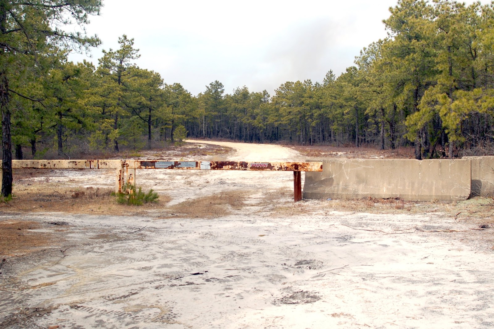
March 15, 2013 photo by Pete Stemmer
Steve and I got out of the truck to read the signs posted on the barrier.

March 15, 2013 photo by Pete Stemmer
The signs read:
Restricted Area - Unlawful to enter this area without authorization of the Installation Commander.
. . . on this Installation all personnel and the property under their control are subject to search. Use of deadly force authorized.
After Steve read that last line, he hightailed it back to the truck. For a man with a bad back, he sure could move! Needless to say, we got out of there pronto.

March 15, 2013 photo by Pete Stemmer
Tune in next week for the last installment of Appleby Estates. Find out what was beyond that concrete and steel barrier and the status of Appleby Estates today.
Pete S
Cub Scout Pack #7 did a lot of hiking & camping along this sand road..about 1976.
ReplyDeleteair jordan shoes
ReplyDeleteair jordans
kobe shoes
jordan shoes
balenciaga sneakers
golden goose
birkin bag
moncler outlet
supreme sweatshirt
yeezy shoes
xiaofang20191220