How to add a posting below . . .

To add a new posting, send an email to me at bassriverhistory@gmail.com with a comment, question, story, photo, observation, etc. It will be posted below, shortly after the email is received. To comment on an existing posting, click on the "comments" command below the posting and type your comment. Your comment will show up immediately.   Pete Stemmer

Saturday, October 20, 2012

The Old Tuckerton Water Tower

The August 30, 2012 Blog featured a 1890's photograph (below) of a horse drawn railroad side car with a barn and windmill in the background.

Click on the above photo to go to the 8/30/12 Blog Entry.

The windmill in the photo was the subject a few comments: 

I was just looking at the 1895 Sanborn fire insurance map for Tuckerton and see a windmill noted behind the bank (now Tuckerton Liquors) and the funeral home. There are still concrete piers there that may have been associated with the windmill. Perhaps this is the windmill in the photo? German Georgieff

Great idea to look at the Sanborn Fire Insurance maps for Tuckerton; however, I don't think the windmill behind the bank is the same windmill that is in the photo. P Stemmer 

The concrete piers behind the old bank/funeral home are the base of the old TUCKERTON water tower, seen in many old town pictures. Arnold Cramer

My good history buddy, Shirley Whealton, tells me that the concrete foundation at the rear of the old bank, now a liquor store on Rt 9, is from an old water tower, not a windmill. P Stemmer

It is obvious from the comments that the windmill in the photo is not linked to the concrete foundations behind the old Tuckerton Bank Building as suggested by German Georgieff.

The old Tuckerton Bank on Rt 9 is now a liquor store.

Arnold Cramer and Shirley Whealton correctly pointed out the the concrete foundations are remnants of the old Tuckerton Water Company tower. These foundations, which look like a miniature Stonehenge, can be clearly seen in the following aerial photo.
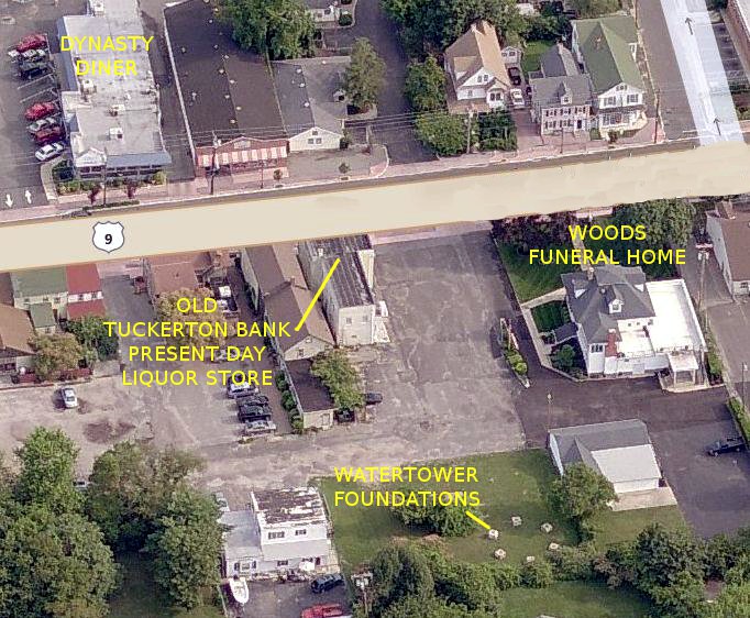
Map courtesy of Bing Maps

Seeing the old water tower foundations got me thinking about the origins of the Tuckerton Water Company and when the tower was built. I asked some Tuckerton old timers if they knew when the water tower was built, but no one seemed to know. It's not surprising, as there are no eye witnesses of the tower being built, as I discovered, while reading some Tuckerton Beacon "Out of the Past" news articles, that it was constructed in 1898.

A series of brief Tuckerton Beacon articles chronicles the formation of the Tuckerton Water Company and the building of the tower.

The Tuckerton Water Company was granted a franchise in 1898 with the condition that it would provide 5 free fire hydrants throughout the town.


The 45,670 gallon water tank was completed by the Tippet & Wood of Phillipsburg, N.J. at the end of June, 1898


The water for the tower was obtained from the headwaters of Lake Pohatcong to ensure that the water was pure.


Half price specials were offered to induce new subscribers to hook up to the newly available water service. It sounds a lot like today's advertising.


The Everett House, a popular hotel on Tuckerton's Main Street, was the first to connect to the new water system.

Photo courtesy of the Tuckerton Historical Society.

The services of the new water company were so popular that plumbers were in high demand. Not having air conditioning, it seems a cool bath in the hot summer hit the spot with many residents.


Common stock was issued to raise capital for the start up costs of the water company. The stock certificates list the official name of the company as the Tuckerton Water Works Co.


The total value of the stock issued in 1898 was $12,000.00. Adjusted for inflation, that value would be about $320,000 today. That is a very modest sum to start up a water company today.


Following are a few postcards, from the Tuckerton Historical Society's collection, showing views of Tuckerton taken from the water tower. If you recognize any of the buildings or can estimate when the photos were taken, let's hear from you!


Notice the outhouses lined up like soldiers behind a group of houses and Lake Pohatcong in the background in the following postcard.


Lake Pohatcong can also be seen in the view below.


Unfortunately, I haven't been able to locate a photo of the water tower, nor do I know when it was dismantled. If anyone out in the Blog-O-Sphere can help me with these issues, I would appreciate hearing from you.

Pete S

Tuesday, October 9, 2012

Stage Road and the Starship Enterprise

A few months ago Jackie and I had to go to center city Philadelphia. It's not my favorite trip; however, the drive through Hammonton to catch the Atlantic City Expressway at Williamstown, and over to the Ben Franklin Bridge to Philly only takes about an hour and 15 minutes. All in all, it's not a long trip, but the traffic sure is heavier than in good old New Gretna and finding a parking place can be frustrating.

As I was cruising up the Expressway, my thoughts wandered to one of my all time favorite TV shows - Star Trek. 

The crew of the Starship Enterprise

I got to thinking that Captain Kirk wouldn't have to fight traffic on his way to Philly. A trip to the Enterprise's Transporter room and a simple command to Scottie to beam him to center city, and the good captain would be walking in Philly within a few seconds. It sure beats my hour and 15 minute journey, and Kirk wouldn't have to fight for a parking spot.

This futuristic journey to Philly seems unimaginable to us, today; however, man's quest for progress would tend to prove otherwise. After all, an hour and 15 minute trip from Tuckerton to Philadelphia would have seemed just as preposterous to the Tuckertonians in the 17th century as a 3 second trip to Philadelphia seems to us today.

Back in the early 1800's a trip from Tuckerton to Philadelphia would take a few days by stage coach. 


The main route was Stage Road which ran from Tuckerton on sand roads through the Pine Barrens to Camden where a ferry trip would take the traveler across the Delaware River to Philadelphia. Multiple stops would be made along the way at taverns strategically placed at distances allowing the stage coach to change horses and the travelers to stretch their legs and partake of refreshments. The trip would require a nights lodging in the middle of the Pine Barrens, often in less than desirable circumstances. Heat and high humidity combined with hoards of mosquitoes, pine flies, and green heads in the summer and the freezing cold of winter made the trip a challenge.  It was clearly not a journey for the faint or weak hearted.

Steve Eichinger, my history buddy, wrote about traveling along Stage Road from Tuckerton to Philadelphia, highlighting the many taverns along the way. You can read his Stage Road articles which appeared in the June, 2002 and June, 2003 issues of the Bass River Gazette by clicking on the 1820 Tuckerton Stage newspaper ad below.


The July 18, 1820 newspaper clipping advertises a Monday and Thursday trip a week from Tuckerton to Camden followed by a ferry ride to market Street in Philadelphia. On the return trip passengers could disembark in Tuckerton and take a ferry to the beaches on Long Beach Island where they could procure room and board for $4.00 a week. The stage ride cost $2.00.

Following is an August 27, 1840 ad which hawks stage rides from Philadelpia on Wednesdays and Saturdays to Tuckerton for $1.50 and to Manahawkin for $2.00. It lists the route as ferrying to Camden then traveling through Marlton, Tauton, Atsion, McCarthyville, Bass River, Tuckerton, and Manahawkin. McCartyville was a papermill town which later became Harrisville.


The ads sure put traveling from Tuckerton to Philadelphia in perspective. I guess I can't complain when I'm caught in heavy Expressway traffic. After all, it's better than a day or two's stage travel over bumpy old Stage Road. It seems that I'm Captain Kirk to that 17th century stage coach traveler.  Beam me up, Scotty!

Pete S

PS- A special thanks to Paul Schopp, a history colleague, who provided the Tuckerton Stage ads.

Tuesday, October 2, 2012

New Gretna News- January 14, 1943

It's been a while since I posted here at the Blog. Sorry about that! It's due to a combination of writer's block and computer problems. Hopefully, I'll be able to get back in the grove with weekly Blog posts.

I thought I'd take you on a trip back to New Gretna in the early part of 1943 via a clipping from the January 14, 1943 Tuckerton Beacon. It was the beginning of the year I was born and the middle of the war years. We see mention of a few New Gretna boys who served in the war. There were many young men and women from New Gretna that served in the war.


Rev. Huckaby and family - 1961


Private Harold Gerew


Win Salmons


Ruy and Marietta Allen


Delwin Downs in Clarence Mathis' store


Jack Mathis


Milton and Mildred Kauflin


I hope that the news clipping and added photos bring back some memories for some New Gretna old timers out in the Blog-O-Sphere. If so, let's hear from you.

Pete S

Thursday, August 30, 2012

The Tuckerton Side Car Photo Mystery

I received an email from a history buddy, Pete Hamilton, the Web Master of the West Jersey History Project web site. He also hosts a sister site on Facebook where Richard Gibbs posted a photo of an interesting Tuckerton scene from the 1890's. Richard knew the photo was taken in Tuckerton but could not identify where it was taken. Pete was hoping that I could help.

Tuckerton, 189_ was written on the back of the photo.

Unfortunately, I had no idea where the photo of the horse drawn railroad side car was taken. There were; however, some obvious clues: railroad tracks, a gravel road, a farmhouse nestled in trees, a barn, and a windmill. I decided to take the photo to the Tuckerton Historical Society. Perhaps, someone there could put the clues together and figure out where the photo was taken.


There were many clues on the 189- photo.

I was not disappointed. Patti Richmond, President of the Tuckerton Historical Society, took one look at the photo and said that it was probably taken on Route 9 just north of the present day 7-Eleven. She remembered hearing from old timers that a spur of the old Tuckerton railroad crossed Rt 9 at that location on its way from the main track to Edge Cove on Little Egg Harbor Bay. She also said that the house in the photo was still standing.

Following is a map showing the Tuckerton Railroad route from Tuckerton to Whiting, New Jersey. Take note of the spur which run down to Edge Cove.


The Tuckerton Raidroad by John Brinckman, p 108

My next task was to document Patti's opinion of the photograph's location. Was it at the intersection of present day Rt. 9 and the old Edge Cove railway spur?

The Woolman and Rose 1878 map of Tuckerton reveals some important clues.

Woolman & Rose 1878 Atlas of New Jersey Coast
Partial Tuckerton map, page 309

The map shows that the Edge Cove spur crossed two roads on its way from the main line to Edge Cove - Wood Street and Main Street (present day Rt. 9). An onsite visit to both of these locations with the photo and the 1878 Woolman and Rose map in hand indicated that the building locations and styles and the road angles at the Wood Street intersection did not line up with the photograph. The Main Street intersection was more promising!

Following is a present day aerial photo of the Main Street-Edge Cove spur intersection site. Unfortunately, there are no existing remnants of the old spur to exactly pinpoint where it  crossed Main Street. However, clues from the old photo and the Woolman and Rose map, when placed on the aerial map, give a good indication of the spur's location.


Present day aerial map courtesy of Bing Maps

The spur ran parallel to a creek which passed under Main Street. The creek is not there today; however, the creek bed can still be seen in a wooded area west of Main Street. 


The creek in 1878
Woolman & Rose Atlas of New Jersey Coast

The Captain's Carpet property, at the intersection with Tip Seaman Drive, now covers the old creek bed to the east of Main Street. A swale can be seen to the right of the building, its indentation a remnant of the old creek bed. It is likely that Tip Seaman Drive was built over the old Edge Cove spur roadbed.

Captains Carpet now stands at the corner of Tip Seaman Drive and Rt. 9.
It sits on the old creek bed which ran parallel to the Edge Cove spur.
August 29, 2012 photo by Pete Stemmer

A comparison of the roof line and chimney location of the farmhouse in the old rail car photo to that of an existing house also matches. The barn in both the old photo and the Woolman and Rose map are long gone.


The farmhouse in the old photo, today.
August 29, 2012 photo by Pete Stemmer

Perhaps the most famous owner of this house was Frank Austin, the first mayor of Tuckerton. 


Frank Austin, the first mayor of Tuckerton

I believe Austin lived in this house in the 1890's when the old horse drawn rail car photo was taken. The 1900 Little Egg Harbor census confirms this as Frank, his wife, Sophia, two children, and a servant were listed as living on the north side of East Main Street.


A review of his neighbors listed on the surrounding census pages, which are too large to post here, show that two Jones families lived adjacent to Frank's home and the Lippincotts lived across the street. This agrees with the surrounding families listed on the 1878 Woolman and Rose map. Austin had to have moved to this house between 1878, when the 1878 Woolman and Rose map shows A. Parker living there, and the 1900 census. 

Shirley Whealton, my genealogy mentor and history buddy, told me that she either read about or saw a photo of Frank Austin's house with a windmill in the yard. Unfortunately, she couldn't remember specifically where she got that information. I have not been able to document her claim; however, the windmill in the old photo Tuckerton side car photo tends to confirm it.

I took the following photo from the spot that, I believe, the photographer stood who took the rail car photo. The old Edge Cove spur would have run just past the Rt. 9 cross walk. Somehow, I believe the view looked better a hundred or so years ago.


Well, that's my tale of the mysterious Tuckerton side car photo. I hope you enjoyed the journey as much as I have.

Pete S

PS- Those of you out in the Blog-O-Sphere who enjoy New Jersey History should pay a visit to Pete Hamilton's web and Facebook site. The Facebook site has tons of interesting New Jersey photos and post cards. You can visit them by clicking on the links below.


CLICK HERE to visit the
West Jersey History Project Web Site

CLICK HERE to visit the
West Jersey History Facebook Site


PPS- The 189_ photo of the railroad side car is reminiscent of the Clamtown Sail Car May 6, 2009 Blog entry. Click on the sail car photo below to see that entry.

Monday, August 20, 2012

The Great Underwear Heist of 1940

Government theft and fraud cases scream out in many of today's TV news shows and newspaper headlines. We sometimes think that it is something new due to a falling of our national moral values, but that may not be the case. I've heard it said that human nature doesn't change and, the following may be a case in point.

A CCC Camp was run at the Bass River State Forest in the late 1930's and early 1940's. Its purpose was to provide jobs and constructive work for the nation's unemployed. It was part of Roosevelt's New Deal.

Men lining up at the Mess Hall at the Bass River CCC Camp
(Photo courtesy of John Nisky)

The Bass River CCC Mess Hall
(Photo courtesy of John Nisky)

Inside the Bass River CCC barracks
(Photo courtesy of John Nisky)

Men came to the Bass River CCC Camp from all over the Atlantic region. City types were mixed with country and farm boys making Bass River a little melting pot as the newcomers interacted with New Gretna locals. It was generally, a positive situation as much could be learned in this mixed cultural environment; however, what I said previously about human nature, is illustrated in the following February 22, 1940 article from the Trenton Times.

The stakes, clearly, aren't as big as today's $900 toilet seat type thievery used by today's modern era, sophisticated crooks, but the motive is the same .   .   . GREED!

Seems that a certain Preston Hoyt, a CCC employee, likely a city boy, sold some CCC property to Towers Loveland, a local boy, to make a few bucks. The caper was somehow uncovered, and the matter went to court.


The case untimately boiled down to a pair of Long Johns. 


Judge Forman, evidently mindful of the value of the pilfered goods versus the cost of the operation of the justice system,  dismissed the case.

Did justice prevail? I don't think so. Somehow, I believe the case could have been better served by Judge Judy. She'd never be caught with her shorts down!

Pete S